
Every crisis leaves lessons behind.
In our monthly Crisis Series, Phoenix Resilience examines real-world events and the decisions that influenced their outcomes.
This month we are talking about Natural Hazards
The Crisis Series: Natural Hazards
September 1, 2026
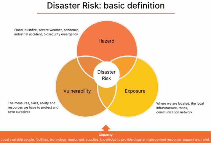
The United Nations Office for Disaster Risk Reduction (UNDRR) states that there is no such thing as a "natural disaster"; instead, it defines disaster as a serious disruption caused by natural hazards interacting with exposure, vulnerability, and capacity (see Model 1).
The UNDRR then defines a hazard as a process, phenomenon, or human activity that may cause loss of life, injury, health impacts, property damage, socio-economic disruption, or environmental degradation.
Meanwhile, natural hazards are natural processes or phenomena such as earthquakes, floods, or storms.
For an organisation, this covers natural hazards negatively impacting our people, operations or assets/infrastructure/equipment and causing operational, legal, financial and/or reputational consequences.
Boxing Day Tsunami (2004)
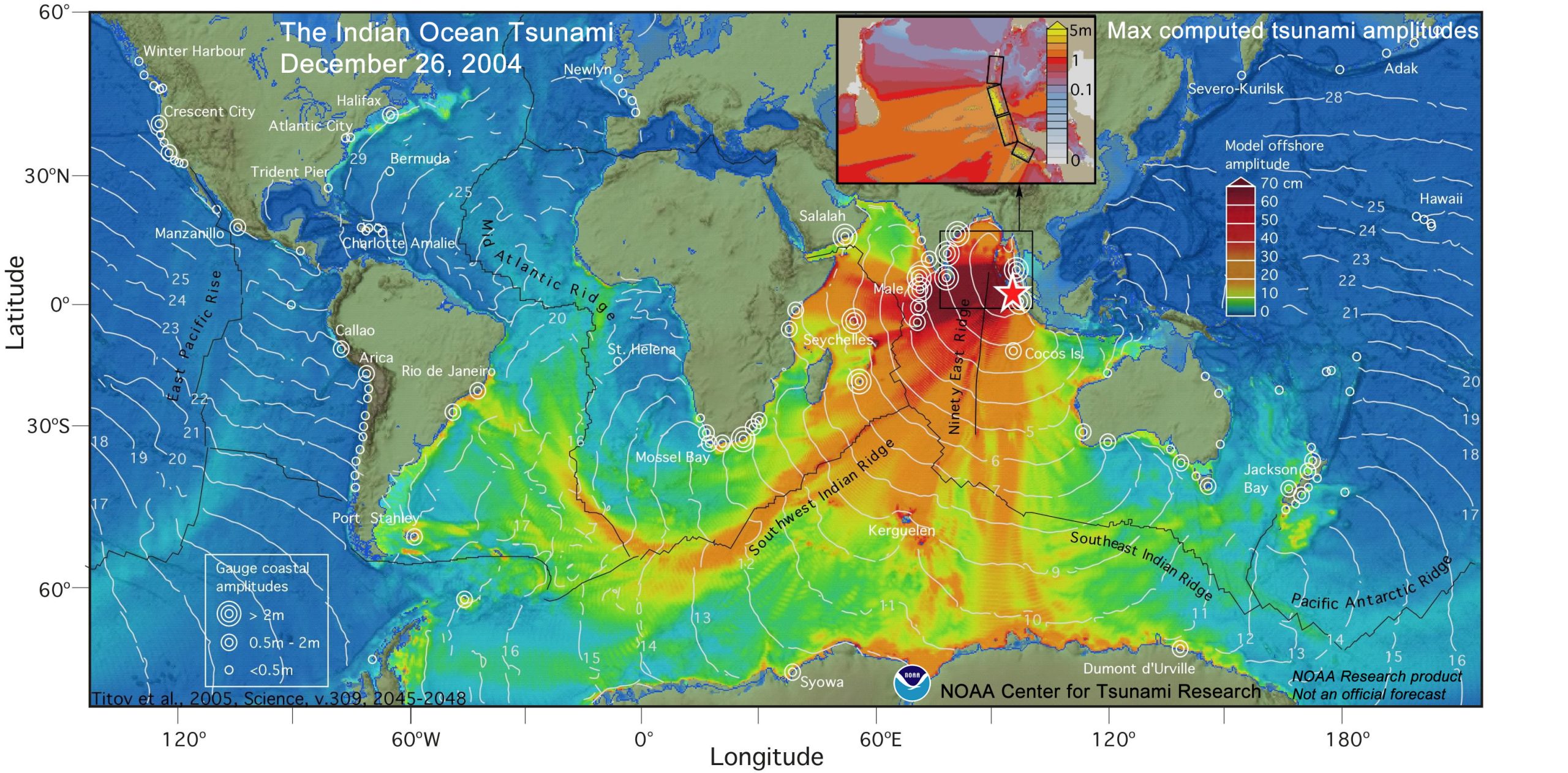
The 2004 Boxing Day Tsunami was one of the most devastating disaster events in modern history.
It occurred on 26 December 2004 when a powerful undersea earthquake with a magnitude of approximately 9.1–9.3 struck off the west coast of northern Sumatra, Indonesia. The earthquake caused a sudden displacement of the ocean floor, generating a series of massive waves that spread across the Indian Ocean, affecting more than a dozen countries.
The defining features of this natural crisis were the extreme magnitude of the triggering event, the widespread geographical impact, and the inability of affected communities to adequately prepare for the disaster.
Indonesia, Thailand, Sri Lanka, India, and the Maldives, among others, experienced immense destruction as the waves reached coastal areas within hours of the earthquake.
The tsunami caused an estimated 230,000 deaths across 14 countries, displaced millions of people, and destroyed countless homes, infrastructure, and livelihoods.
The crisis was intensified by several factors, including limited tsunami warning systems in the Indian Ocean region at the time, dense populations living near vulnerable coastlines, and a lack of public awareness about tsunami risks.
Many communities had little or no warning before the waves arrived, resulting in significant loss of life.
The destruction of roads, communication networks, and essential services also created major challenges for emergency response and recovery efforts.
The Boxing Day Tsunami demonstrates the importance of disaster preparedness, early warning systems, and international cooperation in reducing the impacts of natural hazards.
Following the event, many countries, including Indonesia, India, Sri Lanka, Thailand, the Maldives, and Australia, worked together to establish the Indian Ocean Tsunami Warning and Mitigation System. Governments also invested in improved coastal planning, evacuation infrastructure, hazard mapping, public education campaigns, and regular emergency drills to better prepare communities for future tsunami events. This regional cooperation has significantly improved early warning capabilities and disaster preparedness across the Indian Ocean.
 Critical Risk Mitigation: Early Warning
The more warning you have before impact, the more time you have to mitigate the risks.
This event highlighted the importance of early warning for communities and organisations.
To reduce our disaster risk exposure, we need to explore where and how we can increase our early warning capability. This can mean signing up to hazard apps that provide warnings and notifications, establishing clear internal warning and notification protocols, or resourcing a permanent monitoring capability.
Hurricane Katrina (2005)
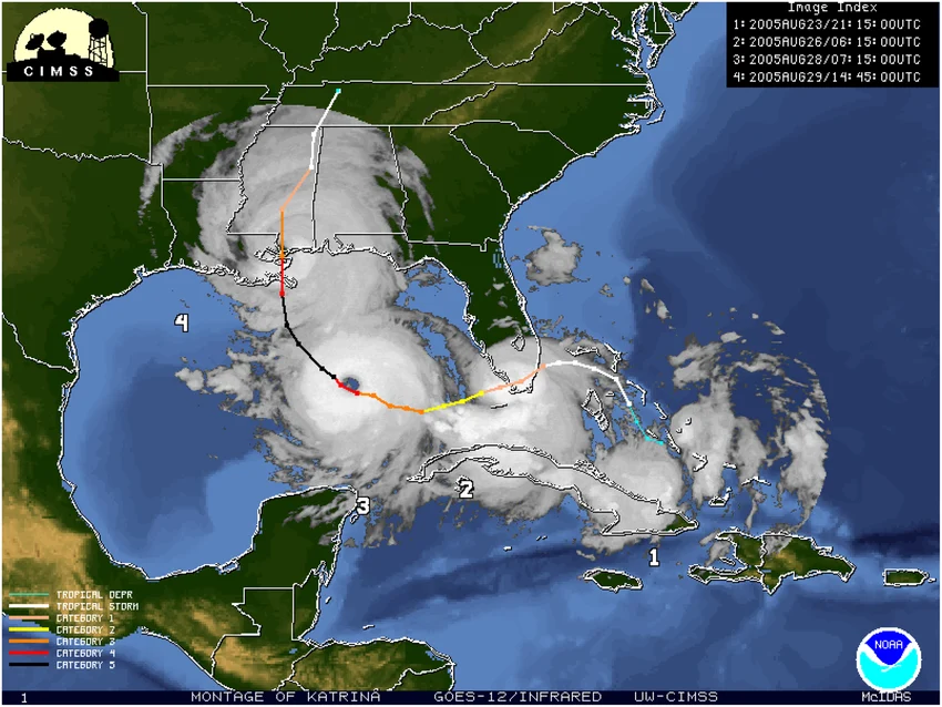
Hurricane Katrina made landfall on 29 August 2005 along the Gulf Coast, particularly affecting Louisiana, Mississippi, and Alabama.
This Category 5 hurricane formed over the Atlantic Ocean and intensified as it moved through the Gulf of Mexico, producing powerful winds, heavy rainfall, and a hazardous storm surge that overwhelmed coastal defences.
The defining features of Hurricane Katrina as a natural hazard were the storm’s extreme severity, combined with the vulnerability of affected communities, and the failure of infrastructure and emergency systems to sufficiently manage the disaster.
The storm surge caused widespread flooding, particularly in New Orleans, where 80% of the city became submerged after failures in the levee system designed to protect the city.
The disaster resulted in more than 1,800 deaths, displaced hundreds of thousands of people, and caused billions of dollars in damage to homes, businesses, and infrastructure.
The impacts of Hurricane Katrina were worsened by social and environmental factors.
Many residents, particularly low-income communities, lacked the resources or ability to evacuate before the storm.
On top of this, delays in emergency response, communication failures, and coordination issues between government agencies increased the crisis severity.
Hurricane Katrina highlighted the importance of effective coordinated emergency management.
Following the event, significant changes were made to improve hurricane forecasting, evacuation planning, and flood protection systems in vulnerable regions.
 Critical Risk Mitigation: Coordination Arrangements
Knowing who is responsible for what, and ensuring those responsible are resourced and have the authority to deliver on their remit, is critical for a swift and effective response to natural hazards impacting your organisation. Do not make assumptions: confirm who is responsible for what, confirm they have the resources, capacity and mandate to act, and confirm you have collaboration structures in place to make cross-organisational decisions and effectively work together. This could be captured in a Crisis Management Plan that is implemented, communicated and regularly practiced.
Haiti Earthquake (2010)
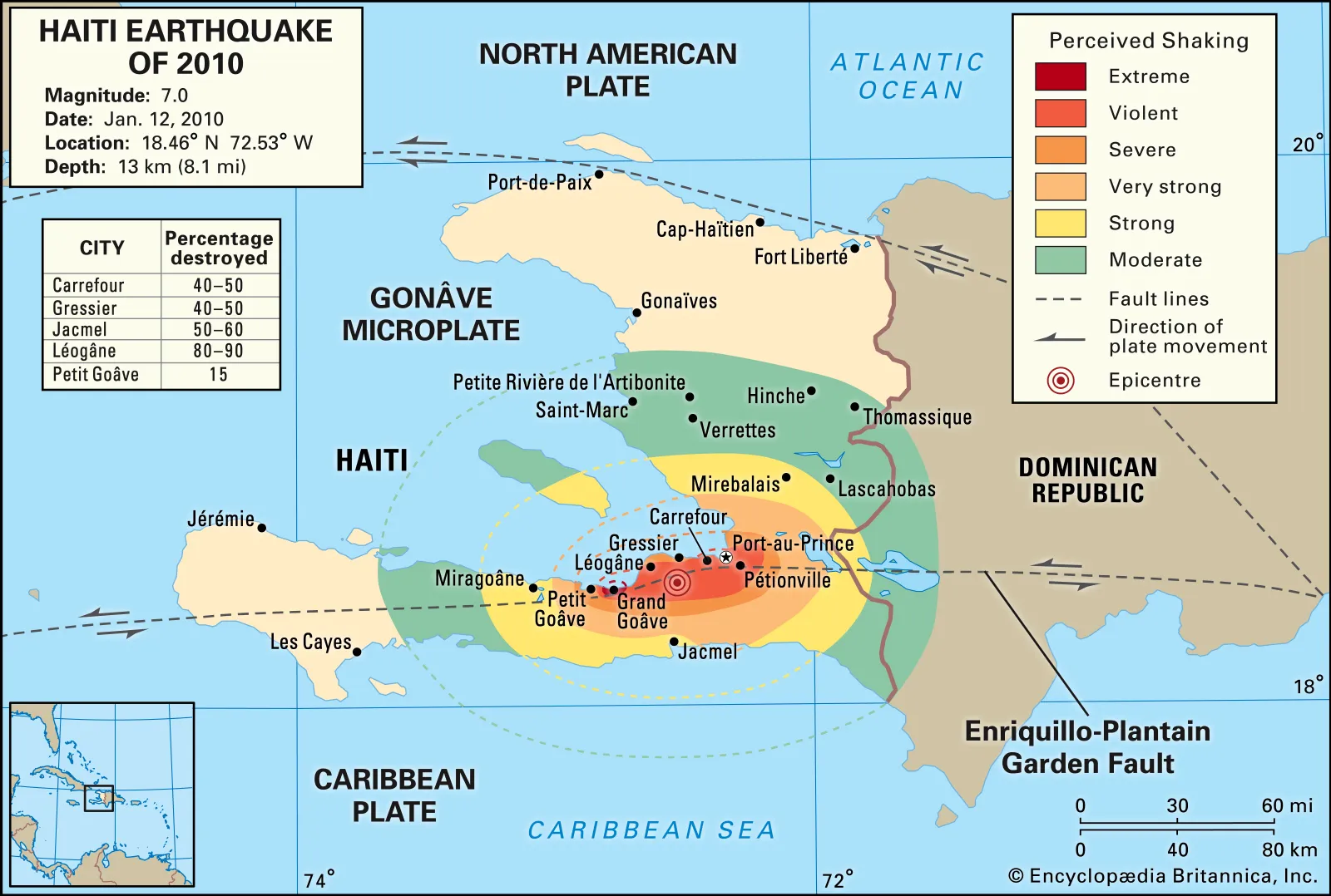
On 12 January 2010, a powerful magnitude 7.0 earthquake struck near Haiti’s capital city Port-au-Prince. The earthquake caused widespread destruction across Haiti, a country already facing significant economic and infrastructure challenges, resulting in a major humanitarian crisis.
The earthquake caused thousands of buildings to collapse, including homes, hospitals, schools, and government facilities.
It is estimated that more than 200,000 people were killed, hundreds of thousands were injured, and over one million people were left homeless.
The impact of the disaster was amplified by Haiti’s limited infrastructure, high population density in urban areas, and lack of strong building regulations.
Many structures were not designed to withstand major earthquakes, which caused widespread building failures and left people trapped beneath rubble.
The destruction of communication networks, roads, and medical facilities also created major challenges for rescue operations and the delivery of essential supplies.
The crisis required a large-scale international response, with humanitarian organisations, foreign governments, and rescue teams providing emergency assistance.
Recovery efforts were complicated by resource shortages, coordination difficulties, and additional challenges such as disease outbreaks in displaced communities.
The Haiti earthquake demonstrated that the severity of a natural disaster is influenced not just by the strength of the event but also by the preparedness and resources of the affected society.
 Critical Risk Mitigation: Resilient Infrastructure and Processes
You will not always get a warning or notice, sometimes impact happens suddenly. Ensuring that your infrastructure and processes can deal with disruption is key.
Resilient infrastructure includes for example possessing backup power generation, having access to multiple telecommunications providers, and operating from resilient facilities that can withstand earthquake, flood and fire.
Resilient processes include for example manual workarounds, cross-trained staff, ability to work remotely, and robust supply chains.
Black Saturday Bush Fires (2009)
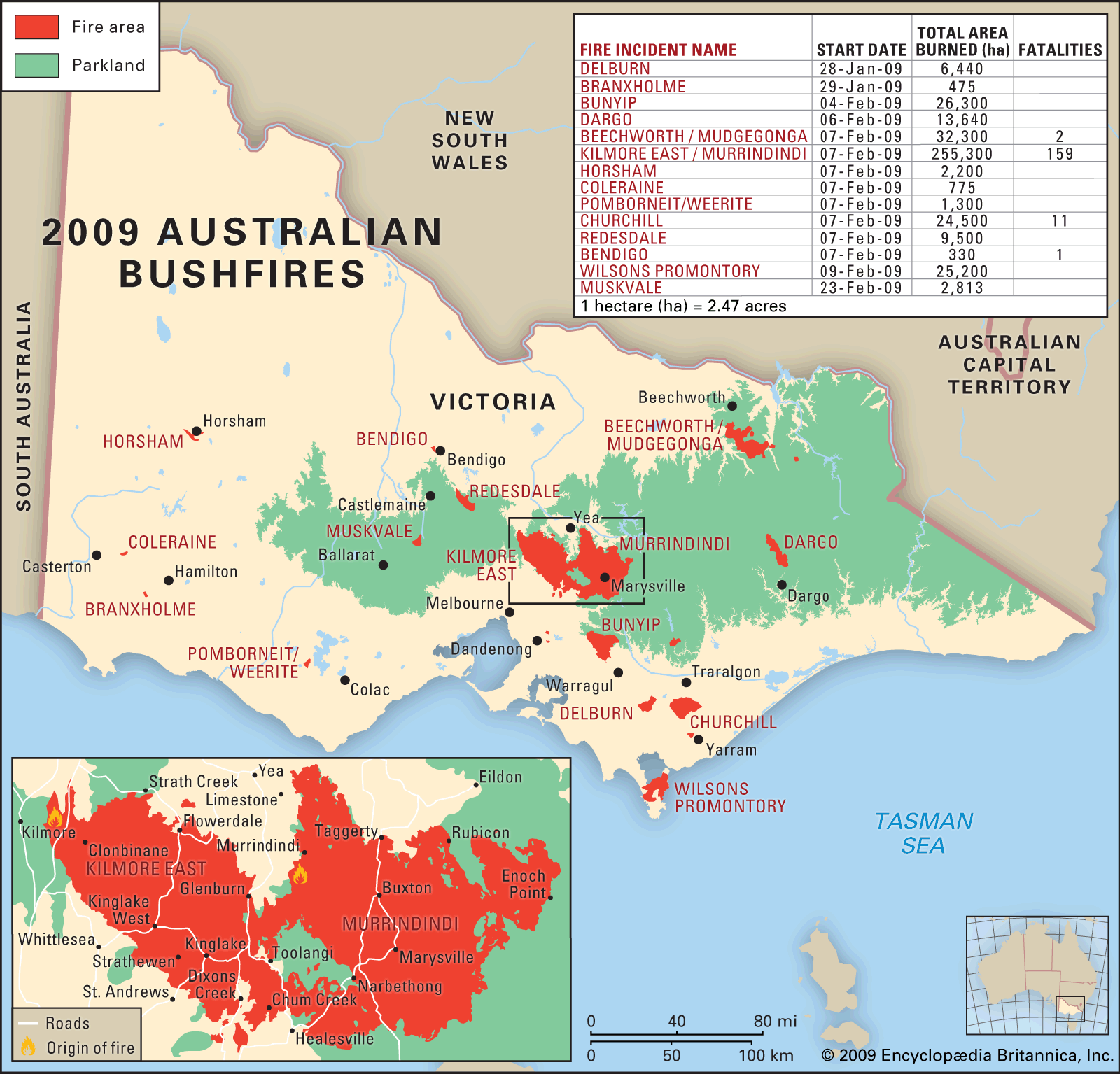
The Black Saturday bushfires affected Victoria in February 2009 during a period of extreme heat, dry conditions, and strong winds.
A series of intense bushfires spread rapidly across large areas, particularly in the regions surrounding Melbourne, causing widespread destruction to communities, infrastructure, and the environment.
The disaster resulted in 173 deaths, more than 400 injuries, the destruction of over 2,000 homes, and left thousands of residents displaced.
The severity of the crisis was increased by the vulnerability of rural communities located near dense bushland areas and the difficulty of controlling fires under extreme heat conditions.
Many residents had limited time to evacuate as fires quickly changed direction due to strong winds.
Emergency services, including firefighters and rescue organisations, faced significant challenges due to the scale and intensity of the fires.
The Black Saturday bushfires led to major reviews of Australia’s bushfire management and emergency response systems.
The 2009 Victorian Bushfires Royal Commission identified improvements needed in areas such as community warnings, evacuation planning, land management, and emergency communication systems.
These changes contributed to the development of improved fire danger ratings and public safety procedures.
 Critical Risk Mitigation: Communication
Communicating across multiple organisations requires common systems, shared terminology, standardised warnings, clarity on the call to action, and agreed response protocols.
One way to achieve that is by adopting the structures, processes and terminology outlined in the Australasian Inter Service Incident Management System (or local equivalent, such as USA NIMS or New Zealand CIMS). This standard can be easily customised to suit your operating context and enhance interoperability.
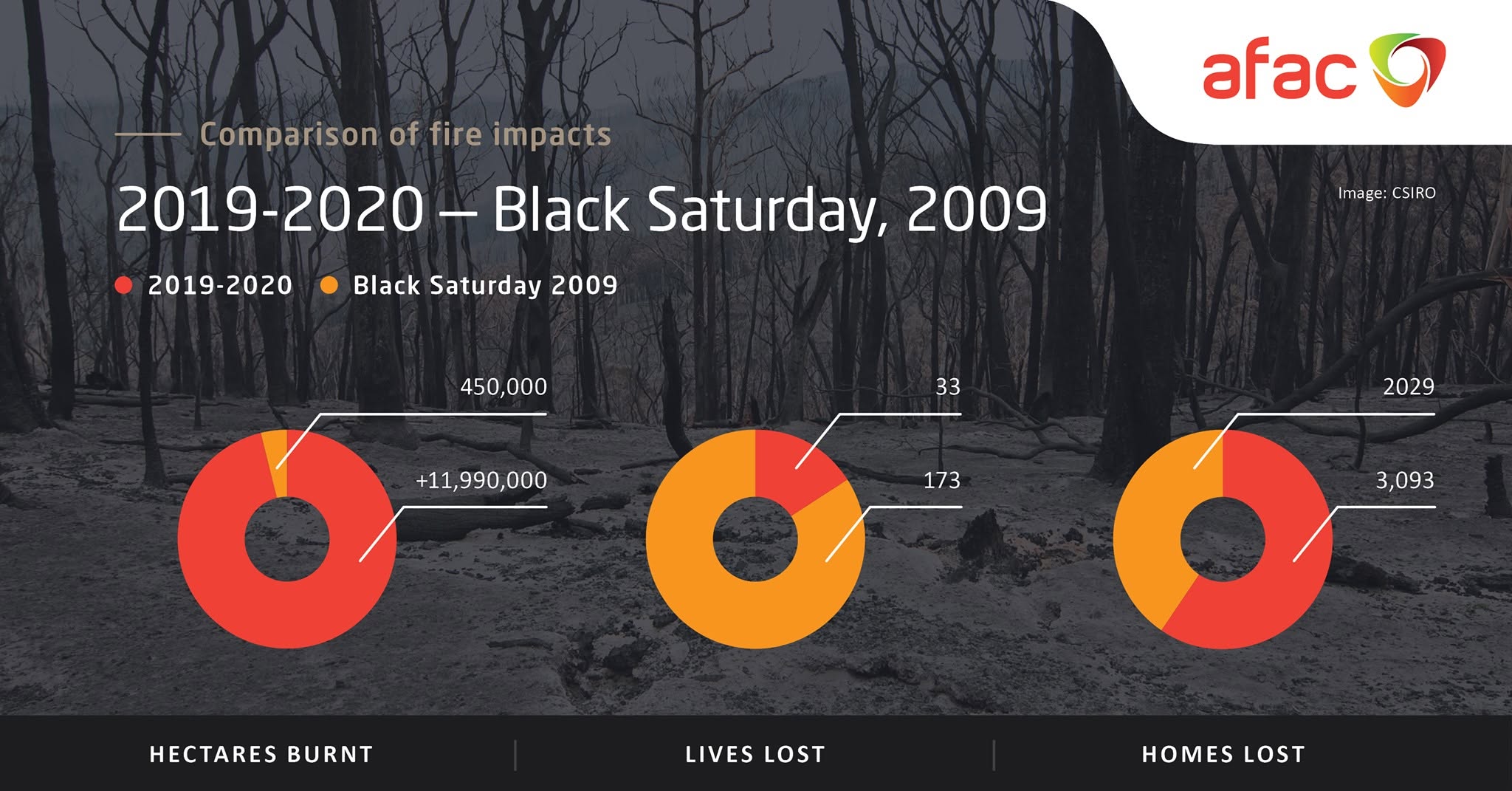
Arguably, as a result of implementation of findings of the Victorian Bushfire Royal Commission of 2009, and the inclusion of Intelligence and Public Information functions in AIIMS (Australasian Inter-service Incident Management System) 2017 there is reduction of lives lost and relative losses of infrastructure when when comparing the impacts of the 2009 Black Saturday bushfires with the 2019-2020 Summer Bushfires.
The AIIMS manual (current version 2025) stresses the importance of sharing "timely, tailored and relevant information" about an incident with affected communities.
Current and Future Considerations
Natural hazards are an increasingly complex global challenge due to climate change, population growth, and expanding urban development in high-risk areas.
A current concern is the developing El Niño climate event, which meteorologists warn could become one of the strongest on record with a high probability of persisting until at least early 2027.
El Niño is a natural climate pattern caused by above-average sea surface temperatures in the central and eastern Pacific Ocean.
Forecasts suggest the upcoming event could increase the likelihood of extreme heatwaves, droughts, bushfires, floods, and severe storms in different parts of the world.
In Australia, El Niño is typically associated with hotter and drier conditions, increasing the risk of drought and bushfires.
Scientists have also warned that a strong El Niño, combined with ongoing climate change, could disrupt agricultural production, contribute to food shortages, and drive higher food prices.
These predictions highlight the importance of climate monitoring, early warning systems, and disaster planning to reduce the impacts of future natural disasters.
The combination of El Niño and other climate factors, such as a positive Indian Ocean Dipole, has previously contributed to severe dry conditions, including the drought conditions that led up to Australia’s 2019–2020 bushfires.
These interactions show that future natural disaster risks may involve multiple overlapping hazards rather than isolated events.
Another important consideration is the role of technology and improved forecasting.
Advances in satellite monitoring, climate modelling, artificial intelligence, and early warning systems allow governments and communities to better anticipate hazards and prepare responses.
Future natural disaster management will require planning, scientific innovation, and continual adaptation to the changing climate.
Although natural hazards cannot be eliminated, improved preparation and resilience can reduce their impact on communities and ecosystems.
How AI Can Reduce Natural Hazards Risks
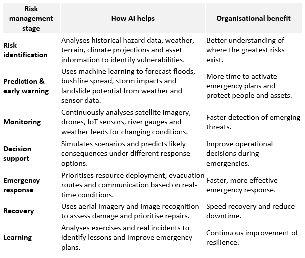
AI can reduce natural hazard risks by helping organisations anticipate, prepare for, respond to, and recover from events such as floods, bushfires, cyclones, earthquakes, heatwaves, and severe storms. While AI cannot eliminate these hazards, it can improve decision-making, reduce uncertainty, and speed up response times.
AI can add value in all aspects of risk management regarding natural hazards:
This article is part of Phoenix Resilience's Crisis Series.
Join us on October 1 for our next instalment as we explore Technological Crises and the lessons they hold for crisis leaders and organisations.
© Phoenix Resilience 2026
More Articles From Phoenix Resilience